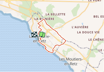
![](/images/other/stat-length.png)
![Tour Wandern La Bernerie-en-Retz - La Bernerie _ Tréans - Photo](https://media.geolcdn.com/t/1900/400/ext.pjpeg?maxdim=2&url=https%3A%2F%2Fmedia.geolcdn.com%2Ff%2F237fba22-9579-41b1-b654-509627a6628f.jpg)
La Bernerie _ Tréans
neoroll44
Benutzer
![Länge](/images/other/stat-length.png)
![Maximale Höhe](https://static1.geolcdn.com/siteimages/upload/files/1508320355ic_sort_altitude_max_24dp.png)
![Positive Höhendifferenz](https://static1.geolcdn.com/siteimages/upload/files/1508320355ic_sort_den_pos_24dp.png)
![Km-Effort](/images/other/stat-length.png)
![Min. Höhe](https://static1.geolcdn.com/siteimages/upload/files/1508320355ic_sort_altitude_min_24dp.png)
![Negative Höhendifferenz](https://static1.geolcdn.com/siteimages/upload/files/1508320355ic_sort_den_neg_24dp.png)
![Boucle](https://static1.geolcdn.com/siteimages/upload/files/16400158638029165_repeat_loop_refresh_sync_direction_icon.png)
![Wandern](https://static1.geolcdn.com/sitytour/trail-icons/101.png)
2h30
Schwierigkeit : Einfach
![Scannen Sie diesen QR-Code, um die Tour in der SityTrail-Anwendung zu öffnen](https://capi.geolives.com/qq0zvz2zws4bq2lad0pu/sitytour/trails/2723975/qr.png?size=200)
Kostenlosegpshiking-Anwendung
Über SityTrail
Tour Wandern von 9,9 km verfügbar auf Pays de la Loire, Loire-Atlantique, La Bernerie-en-Retz. Diese Tour wird von neoroll44 vorgeschlagen.
Beschreibung
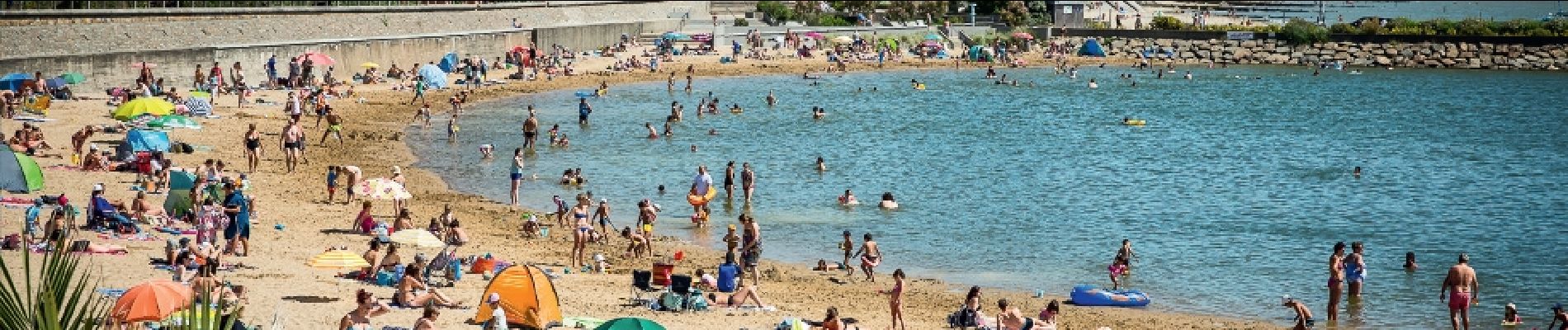
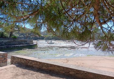
Découvrez les différents visages de la Bernerie-en-Retz, entre mer et campagne, entre plages et champs. Vous passerez à proximité du Moulin des Tréans, bâti au XIIIème siècle.
Départ: En bas de la rue de la mer, au rond-point à proximité du plan d’eau.
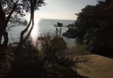
Du point de départ, allez à gauche en direction du plan d’eau de baignade et prenez la promenade Sainte-Anne. A la fin, à marée basse, poursuivez par la plage jusqu’à Port Royal. A marée haute, montez à gauche dans la rue B. Lacroix puis tournez à droite dans la rue des Carrés. Au carrefour, poursuivez en face deux fois. Gagnez le
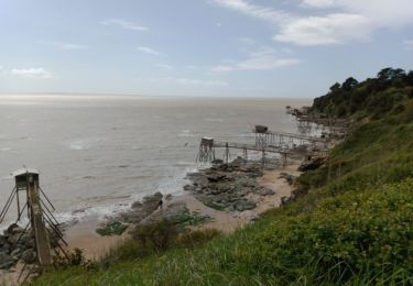
front de mer à Port Royal. Poursuivez et passez le camping.
Remontez à gauche avenue des Magores. Au bout, prenez à gauche
rue de la Baie puis à droite rue de la Sennetière. Traversez la RD 97 et
poursuivez en face rue de la Croix des Noués. Un peu après le passage à
niveau, bifurquez à droite dans le chemin. Au bout, allez à gauche sur la
route et continuez en direction du Moulin des Tréans. Prenez le tunnel et au bout de de la route, allez à gauche.
Poursuivez sur la voie verte. Au Pré Tarin, poursuivez en face. Traversez avec prudence la RD 66 et allez en face en direction de la déchèterie. Continuez tout droit jusqu’à la Blinière.
Au 1er carrefour, allez à gauche, passez sous la route bleue et traversez en face à la prochaine route. Un peu plus loin, bifurquez à gauche dans le chemin.
A la Dénouillère, prenez à droite. Au croisement, dans le lotissement,
allez à gauche avenue de la Noue Fleurie. Au niveau du bois, empruntez
à droite le chemin des Ecureuils.
En bas, tournez à gauche avenue G. Burlot, puis à droite au camping,
empruntez le tunnel sous la voie ferrée. Prenez à gauche rue A. Lucas puis
la rue à droite. Tournez à gauche dans la rue C. Sourdille. Empruntez ensuite l’avenue Guitteny puis prenez la rue de la Paix à gauche. Empruntez la ruelle entre les maisons à droite. Vous rejoignez un parc arboré que vous traversez en vous dirigeant vers la gauche. Sortez à la route et allez à droite vers la mer.
Ort
Kommentare
Touren in der Umgebung
![Tour Zu Fuß Les Moutiers-en-Retz - Le Collet - Photo](https://media.geolcdn.com/t/375/260/ext.jpg?maxdim=2&url=https%3A%2F%2Fmedia.geolcdn.com%2Ff%2F1a57d417-9132-4bf4-870f-21ad0636d79e.jpeg)
![Zu Fuß Zu Fuß](https://static1.geolcdn.com/sitytour/trail-icons/100.png)
Zu Fuß
![](/images/other/stat-length.png)
![](https://static1.geolcdn.com/siteimages/upload/files/16400158638029165_repeat_loop_refresh_sync_direction_icon.png)
![Tour Wandern Pornic - LaFontaineAuxBretons-A - Photo](https://media.geolcdn.com/t/375/260/ext.jpg?maxdim=2&url=https%3A%2F%2Fstatic1.geolcdn.com%2Fsiteimages%2Fupload%2Ffiles%2F1553511878bg_sport_marche.png)
![Wandern Wandern](https://static1.geolcdn.com/sitytour/trail-icons/101.png)
Wandern
![](/images/other/stat-length.png)
![](https://static1.geolcdn.com/siteimages/upload/files/16400158638029165_repeat_loop_refresh_sync_direction_icon.png)
![Tour Wandern Pornic - Canal de Haute Perche - Photo](https://media.geolcdn.com/t/375/260/ext.jpg?maxdim=2&url=https%3A%2F%2Fservices.sitytrail.com%2FGeolivesWS%2FDownloadMedia.ashx%3FTrailID%3D771862%26Media%3D27594949-f20c-4a60-8416-85c35d063bd1.jpg)
![Wandern Wandern](https://static1.geolcdn.com/sitytour/trail-icons/101.png)
Wandern
![](/images/other/stat-length.png)
![](https://static1.geolcdn.com/siteimages/upload/files/16400158638029165_repeat_loop_refresh_sync_direction_icon.png)
![Tour Wandern Pornic - LaFontaineAuxBretons-A - Photo](https://media.geolcdn.com/t/375/260/ext.jpg?maxdim=2&url=https%3A%2F%2Fstatic1.geolcdn.com%2Fsiteimages%2Fupload%2Ffiles%2F1553511878bg_sport_marche.png)
![Wandern Wandern](https://static1.geolcdn.com/sitytour/trail-icons/101.png)
Wandern
![](/images/other/stat-length.png)
![](https://static1.geolcdn.com/siteimages/upload/files/16400158638029165_repeat_loop_refresh_sync_direction_icon.png)
![Tour Wandern La Bernerie-en-Retz - Bernerie_Trou de l'enfer - Photo](https://media.geolcdn.com/t/375/260/ext.jpg?maxdim=2&url=https%3A%2F%2Fstatic1.geolcdn.com%2Fsiteimages%2Fupload%2Ffiles%2F1553511878bg_sport_marche.png)
![Wandern Wandern](https://static1.geolcdn.com/sitytour/trail-icons/101.png)
Wandern
![](/images/other/stat-length.png)
![](https://static1.geolcdn.com/siteimages/upload/files/16400158638029165_repeat_loop_refresh_sync_direction_icon.png)
![Tour Wandern La Bernerie-en-Retz - La BERNERIE en RETZ - Photo](https://media.geolcdn.com/t/375/260/ext.jpg?maxdim=2&url=https%3A%2F%2Fmedia.geolcdn.com%2Ff%2F54207d45-9ea7-4a75-9cd9-948582a4f765.jpg)
![Wandern Wandern](https://static1.geolcdn.com/sitytour/trail-icons/101.png)
Wandern
![](/images/other/stat-length.png)
![](https://static1.geolcdn.com/siteimages/upload/files/16400158638029165_repeat_loop_refresh_sync_direction_icon.png)
![Tour Wandern Pornic - pornic - Photo](https://media.geolcdn.com/t/375/260/ext.jpg?maxdim=2&url=https%3A%2F%2Fmedia.geolcdn.com%2Ff%2F2af5d4f4-9da6-40b2-888a-8e32a57069e0.jpg)
![Wandern Wandern](https://static1.geolcdn.com/sitytour/trail-icons/101.png)
Wandern
![](/images/other/stat-length.png)
![](https://static1.geolcdn.com/siteimages/upload/files/16400158638029165_repeat_loop_refresh_sync_direction_icon.png)
![Tour Wandern Pornic - 2024-01-13 boucle pornic - Photo](https://media.geolcdn.com/t/375/260/ext.jpg?maxdim=2&url=https%3A%2F%2Fmedia.geolcdn.com%2Ff%2F62dfdd50-f639-466e-afe0-ec7c6aed7092.jpg)
![Wandern Wandern](https://static1.geolcdn.com/sitytour/trail-icons/101.png)
Wandern
![](/images/other/stat-length.png)
![](https://static1.geolcdn.com/siteimages/upload/files/16400158638029165_repeat_loop_refresh_sync_direction_icon.png)